| Southern California
|
|---|
![[Cajon Pass]](../socal/cajonpass/pict2567T.jpg)
|
Cajon Pass east of Los
Angeles, where the San Andreas separates the San Gabriel mountain range
from the San Bernardino range.
|
![[Palmdale roadcut]](../socal/palmdale/pict2846T.jpg)
|
The San Andreas Fault through
Palmdale in a famous roadcut off highway 14.
|
![[ images/geology/sanandreasT.jpg ]](/images/geology/sanandreasT.jpg)
|
I found the famous Carizzo Plain unsatisfying. After all I'd heard
about it, it turns out there's not much to see on the ground.
The fault trace and diverted streambeds that look so impressive in aerial
and satellite photos are subtle and difficult to see from the ground,
and would show up better in a mapping project then through simple
visual inspection.
However, at one point, right about when we were supposed to be crossing
the trace, we spotted this, going off in the right direction. I still
don't know if it's fault related -- but none of the normal stream beds
in the Carizzo looked remotely like this.
|
| North of San Francisco
|
|---|
![[San Andreas at Point Arena]](/VolcanoTrip/SanAndreas/Tp8120197.jpg)
|
Point Arena: the Northernmost Landfall
of the San Andreas
|
| The Bay Area
|
|---|
![[ images/geology/sanandreasMBT.jpg ]](/images/geology/sanandreasMBT.jpg)
|
The San Andreas emerging above the sag pond in Montebello
Open Space Preserve, adjacent to Page Mill Rd. above Palo Alto.
This is a wonderful place to explore the fault. Los Trancos
preserve, across the road from Montebello, has a Fault Trail
with (reconstructed) misaligned fenceposts, tilted trees and
other interesting fault signs. Pick up a trail guide at the
trailhead. But Montebello is just as interesting.
Right by this sag pond is a big interpretative sign put there
by MROSD (the agency which administers both parks). Does it say
"Sag Pond on the San Andreas Fault"? No. It says: "Succession",
and talks about the different types of plants that grow in ponds.
I'm sure this makes sense if your degree is in Interpretation
rather than geology or other sciences.
|
![[Crystal Springs Reservoir]](/images/geology/crystalspringsT.jpg)
|
Crystal Springs Reservoir: the repository where San Francisco
keeps the water piped from Hetch-Hetchee in Yosemite.
It and its aptly named cousin San Andreas Reservoir, immediately
to the north, are huge sag ponds across the San Andreas.
Several earthquakes have affected the fault since the reservoirs
were built, but the earthen dams have held up so far.
Another page with good information about local exposures of the
San Andreas is here.
|
|
|
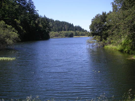
Lake Ranch, a tiny little reservoir in Sanborn County Park above
Saratoga, is another sag pond on the San Andreas. It isn't always
this full of water; often it's completely dry. A fire road above it
zig-zags across numerous fault contacts, from mudstones to
ophiolites (including some gabbro, relatively rare around here,
and chert but relatively little serpentine).
|
![[ images/geology/sanandreasT.jpg ]](/images/geology/sanandreas.jpg)
![[ images/geology/sanandreasMBT.jpg ]](/images/geology/sanandreasMB.jpg)
![[Crystal Springs Reservoir]](/images/geology/crystalsprings.jpg)