A viewer for tiled maps, plus viewing and editing track and waypoint files.
PyTopo is an open source tiled map viewer, written in Python and GRK. It can download and cache tiles from OpenStreetMap or other map tile servers, or you can make your own local tiled maps or use commercial datasets.
PyTopo can also show tracks and waypoints in several different formats, can save favorite places, and has some rudimentary track editing ability.
Downloaded map tiles are cached forever (or until you remove them), so you can download tiles and then use PyTopo offline if, like me, you often travel to places where there’s little or no internet access.
Installing
PyTopo is available on PyPI:
pip install pytopo
It requires GTK and several related dependencies. I’ve tried to include the dependencies in setup.py so pip install will pull them in automatically. Some of the dependencies may require a C compiler and Python development headers.
Once you’ve installed the package, the command to run is pytopo.
PyTopo’s source is hosted on GitHub if you want the latest and greatest.
Using PyTopo
The first time you run pytopo, it will create a configuration file: on Linux that is ~/.config/pytopo/pytopo.sites
You might want to take a look at the file: this is where you can add additional map collections or sites you visit frequently. By default, pytopo will download OpenStreetMap tiles to ~/Maps. Of course, you can change that. See the PyTopo File Formats page for more details.
pytopo -p will print out a list of known sites. With the initial default configuration you’ll just have a few cities like san-francisco, new-york, london, sydney; this is mostly to show you how to add your own points of interest.
Key/Mouse bindings
- Left, Right,<br>Up, Down
- Scroll the map in the indicated direction.
- +/=, -
- Zoom in or out.
- Space, m
- Jump back to the pinned location.
- q
- Quit
With no arguments, will display a list of known sites.
Track files may be in GPX, KML, KMZ or GeoJSON format, and may contain track points and/or waypoints; multiple track files are allowed.
Use decimal degrees for start_lat and start_lon.
Set up favorite site names in ~/.config/pytopo.sites, favorite track logs in ~/Tracks
Dragging and mousewheel move and scroll the map, as you’d expect. Right-clicking in the map pops up a menu of various other options.
Click on a track or waypoint to select it and see what’s known about it.
Usage (commandline arguments)
Usage: pytopo
       pytopo trackfile
       pytopo known_site
       pytopo [-t trackfile] [-c collection] [-r] [site_name]
       pytopo [-t trackfile] start_lat start_long collection
       pytopo -p :     list known sites and tracks
       pytopo -r :     re-download all map tiles
       pytopo -h :     print this message
With no arguments, pytopo will display a list of known sites.
Track files may be in GPX, KML, KMZ or GeoJSON format, and may contain track points and/or waypoints; multiple track files are allowed.
Use degrees.decimal_minutes format for coordinates. Set up favorite site names in ~/.config/pytopo.sites, favorite track logs in ~/Tracks
Some Additional Features
Track and Waypoint Files
Pytopo can read tracks and waypoints from GPX, KML, KMZ, and GeoJSON files, and you can load multiple track files at once. It shows each track in a different color. You can toggle waypoint visibility with the right-click context menu (for when there are too many waypoints and they get in the way of reading the map).
You can select a track by clicking on it, split a track (right-click context menu again), and save a track as GPX after you’ve split it.
Pinning
You can “Pin” a spot on the map and save it as a pinned location in your PyTopo configuration.
Switching Background Maps
Change Background Map in the context menu will list all the MapCollections you have defined, and you can switch between them interactively.
When you first run PyTopo, it will create a file called config/pytopo/pytopo.sites giving you one MapCollection, for the basic OpenStreetMap tile set, and a few major cities as Known Sites.
You’ll probably want to add your own Known Sites, so you can start PyTopo by passing it names of sites near you. There are two ways to do that. You can right-click on any position on the map and choose “Pin this location”, then “Save pin location” and give it a site name. Or if you’re not afraid of editing files, you can edit <i>pytopo.sites</i> to add your own sites by their latitude or longitude.
The pytopo.sites file is also the place to add new MapCollections, and for this you do have to edit the file (see below).
Mileage and Elevation
If you need distance between two points, you can shift-click and PyTopo will print distance and bearing from there to the previous place you clicked. I know that’s not an optimal user interface, but not many people seem to need that feature and I find it useful enough when I need it.
PyTopo does not yet do anything useful with elevation or mileage on track logs within the PyTopo application itself. But it comes with another script called ellie that can show mileage and elevation profiles.
Take accumulated elevation numbers from any program, including ellie, with a grain of salt. They vary considerably depending on how granular the measurements are and how much smoothing the program does.
About Map Tile Data
Downloaded map tiles are cached forever. This is intentional, so it will be useful when not connected to a network. If you don’t want to keep tiles that haven’t been accessed in a while, use a command like one of these (test this first, don’t just blindly paste it! The 90 is days):
find <path-to-maps> -maxdepth 1 -name "*.png" -atime 90 -delete
find <path-to-maps> -atime 90 -iname '*.png' -exec rm {} \;
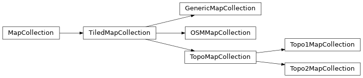
MapCollections
There are lots of different types of MapCollection you can use. The most common is OSMMapCollection, which derives from TiledMapCollection. You’ll define the MapCollections you want to use in your pytopo.sites file.
Most tile servers require you to sign up for an API key. Often the key usually free for light usage, but charges you for heavier usage. You can encode your API key into the URL you set up in the MapCollection.
In the default pytopo.sites, there’s an example of how to use the ThunderForest map server with an API key to retrieve OpenCycleMap tiles. It looks like this, specifying the name of the collection, the location on your local disk to cache the tiles, the size and type of the tiles, the default zoom level (your choice), the URL to use for downloading, the maximum zoom level (this is a function of the tile server), and an attribution string.
- ::
- OSMMapCollection( “opencyclemap”, # collection name
- “~/Maps/opencyclemap”, # where to cache “.png”, 256, 256, # file type and size 13, # default zoom level “https://tile.thunderforest.com/cycle/{z}/{x}/{y}.png?apikey=YOUR_API_KEY_HERE”, maxzoom=22, # maximum zoom level reload_if_older=90, # reload if > 90 days attribution=”Maps © www.thunderforest.com, Data © www.osm.org/copyright”),
You can use the same syntax for many different tile servers to get a variety of different background map tile styles. ThunderForest has several nice styles besides OpenCycleMap: you’ll see their list if you sign up for an API key. You can set up as many MapCollections as you want, either different styles from the same server or from different servers.
Note that the Google Maps terms of service do not allow using their tiles with non-Google mapping apps.
Download Area
Download Area in PyTopo’s menus is intended to make it easy to download a collection of tiles at different zoom levels for a specified area, so you can have the tiles ready when you travel and will be offline. In practice, it doesn’t work very well, largely because most map tile servers will throttle connections that request too many tiles, so it takes forever to download an area. I stopped using it and therefore it isn’t very well maintained, and some map sources will blacklist you if you use it; I recommend avoiding it.
Commercial Map Data
Aside from OpenStreetMap tile srvers, pytopo can use local map data on disk or CD; for instance, from the old Topo! local area and specific park map packages sold in camping/hiking stores, sometimes under the aegis of National Geographic.
For Topo! CD datasets, use a Topo1MapCollection for regions or a Topo2MapCollection for the park map sets:
Topo1MapCollection( "deathvalley", "~/Maps/deathvalley", 7.5, 266, 328 ),
Topo2MapCollection( "kingscanyon", "~/Maps/kingscyn", "topo", 410, 256 ),
Caution: the *Topo! Back Roads Explorer* and the statewide explorer collections are *not* in this friendly tiled format. They use large data files in a proprietary “.tpq” format. Tom Trebisky has analyzed the format and has written an extractor, and he also has a C GTK viewer for this format. I have not tried to integrate support into PyTopo; there are enough good online sources of maps now that I haven’t seen the need to buy any more Topo! datasets myself.
Making Your Own Map Collections
For some areas, you can download USGS topo maps free. For instance, for California you can get maps in TIFF format from the California Spatial Information Library. You also may need to use specialized maps, such as geologic or land-use maps.
To use this sort of map, you have to split the large map into tiles. One way is to use ImageMagick, with a command like:
convert in-map.jpg -rotate 90 -crop 300x300 -repage +0+0 out-map%02d.jpg
Note: previously I included -trim as part of that line, and a lot of pages you’ll find googling for image splitting will tell you to use -trim. Don’t: it will give you maps of inconsistent sizes, and pytopo will have no way to tell where the origin of the map should be.
Maps downloaded as PDF (such as USGS geologic maps) might work in imagemagick, but if not, try converting them to a raster format before splitting, using a program like GIMP or a command like:
gs -sDEVICE=jpeg -r300 -sOutputFile=output-map.jpg input-map.pdf
API Documentation
The primary PyTopo class is the MapViewer, which runs the pytopo application and manages the MapWindow, and all the various MapCollections.
There’s a hierarchy of MapCollection classes for reading different kinds of map tiles. The most important collection class is the OSMMapCollection, used for displaying and downloading tiles from OpenStreetMap, and from the many other servers that implement the same tile naming scheme as OpenStreetMap uses. TopoMapCollection classes are for reading two of the Topo! commercial maps, while GenericMapCollection is a base class for inventing your own map formats, such as map tiles cut from a larger geologic map.
API Documentation: